


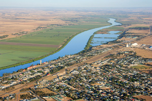
Tailem Bend South Australia facing Murray Bridge
![]()
At the junction of the Dukes and Princes Highways, Tailem Bend is dominated by the River Murray and the railway which was for so long its lifeblood. Its importance as a railhead and workshop in South Australia's railway network may have diminished with time yet the heritage remains. Tailem Bend's riverfront offers caravan parks, camping and boating facilities and makes fishing, strolling and bird-watching a joy. Houseboats can moor at a pontoon and cliff steps lead directly to a comfortable watering hole and restaurants. A short drive west on the Princes Highway takes you to Old Tailem Town Pioneer Village whose 90 restored buildings vividly capture the early days of Mallee settlement. (more information)
 Small rural mallee community
 Moorlands was a settlement that developed around the railway siding on the line to Pinnaroo. It was named after the woolshed nearby that belonged to the Moorlands Station in the pastoral era. The Moorlands Station was named after the Moorlands in Somerset, England. (more information)
Sherlock General Store, South Australia
![]()
Sherlock was named after the Hundred of Sherlock, which was surveyed in 1899 and named after a friend of Governor Buxton. (more information)
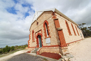
Peake Bapitist Church, South Australia
![]()
Peake was settled in 1912 as a farming community and named after the Premier, Archibald Henry Peake (1909). Along one of the major railway lines of the time, many settlers and travellers passed through. Peake Historical Walk: A relatively short walk allows visitors to see the historic landmarks of Peake. The first is Polly's Well located next to the rest stop, opposite the town oval where pamphlets are also available. Sunk in 1877, the well supplied the town's water. Also you'll find the old Station Masters house (built 1912), the Peake store (built 1937) now the Tavern, the Post Office (1912) and the Bakehouse/Church (1908). The Peake School (1929), Butcher Shop (1900s), Saddlery (1912) and the town Garage which was used from 1956 to 1974. (more information)
 Small rural community with a local store
(pronounced 'jay-buck') is geologically noted for the 'Marmon-Jabuk' fault-line that cuts across the district. Fuel and basic supplies are available from the store on the
highway.
(more information)
Karoonda Pioneer Park
![]()
Karoonda is an important wheat and sheep farming region. The Big Merino Ram is a valued symbol of the town that sits near the railway yards and highlights the importance of sheep farming in the district. Karoonda Farm Fair is a 2 day festival that runs annually in April and well worth a visit as the town comes alive. The Pioneer Park is based on the railways in the Mallee Lands and the Karoonda East Murray District. A fascinating collection of early Mallee memorabilia including buildings, railway and farming machinery, and discover the way of life for the district's pioneers from the 1850s to the 1950s. There is also Aboriginal culture and natural history information with a nearby Nature Trail and Bush Walk. Karoonda is an RV Friendly town. (more information)
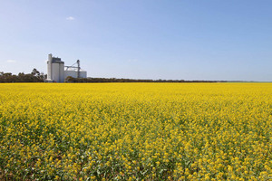
Geranium Canola fields, South Australia
Geranium on the highway has a hall, two churches, a store, a garage, extensive sporting facilities and the only other bowling green in the area makes it an important local centre, and an attractive township for farmers to retire to. In 1999 the Geranium community won South Australia's Tidiest Town Award and won an Award of Excellence for Environmental Action and Education nationally. (more information)
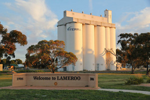
Lameroo Wheat Silos, SA
![]()
Lameroo is the main service centre for the surrounding farming area. Dolly's Golden Rain Tree Crafts and Heritage is the place to gain an insight into the history of the town and district with a browse around the interesting museum. The craft shop is a favourite spot too and visitors can browse for handmade gifts or have a delicious Devonshire Tea with visitor information services available. Today Lameroo welcomes visitors with lush lawned picnic areas and a children's playground on the main street. At picturesque Lake Roberts, on the eastern approach to the town, there are alternative picnic areas and the newly opened and well appointed caravan park. There's an 18 hole public golf course and in summer, a dip in the local swimming pool is very refreshing. The Mallee District National Parks and Wildlife SA office is located in the centre of Lameroo's main street and has information on the various conservation parks, camping grounds and walking trails in the area as well as the Border Track. Ngarkat Group of Conservation Parks features 270,000 hectares of unspoilt natural habitat and is home to 2WD accessible picnic sites and walking trails, 4WD tracks and an abundance of native wildlife. Visit or phone the National Parks office at Lameroo for information Phone (08) 8576 3690. (more information)
Parilla Hotel, South Australia
![]()
Parilla is named after an Aboriginal word meaning 'cold place'. It was surveyed in 1904 and proclaimed a town in 1907 but, like Lameroo and Pinnaroo, it came to life in 1906 with the arrival of the railway. This Mallee area has both traditional and newer crops including potatoes, carrots, onions and olives. Parilla is a great spot to take a break from travelling at the well appointed rest area including toilets and shower block opposite the local Parilla Hotel and general store. There is a children's playground nearby. A short walk nearby reveals an amazing historic Parilla wall mural. (more information)
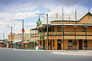
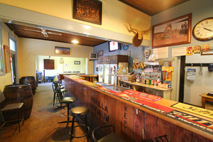
Pinnaroo Hotel, South Australia
![]()
The Pinnaroo township has good shopping and service facilities, swimming pool and other recreation amenities such as golf, lawn tennis, bowls and croquet plus various sports held at the school gymnasium. It has an award winning bakery opposite the Mallee Tourist and Heritage Centre. The centre provides information on local attractions has excellent displays relating to the district's history. Displays include farm machinery, cereal grain collection, farm and household memorabilia, letterpress printing machinery and more. Pinnaroo is a good base to explore the conservation parks in the area. Some 15km south of Pinnaroo and adjoining the Ngarkat Conservation Park is the Scorpion Springs Conservation Park. It is a natural soakage which is a haven for the native animals and birds, and alive with native shrubs in the spring time. The Karte Conservation Park is 30kms north-west of Pinnaroo on the Karte Road. The Park contains a 1.5km Walking Trail where native flora and fauna may be viewed. The Peebinga Conservation Park is 30kms north-west of Pinnaroo on the Loxton Road. The Agricultural Show, held on the first Wednesday after the October holiday, is regarded as one of the best Country Show's in South Australia. (more information)
Other historic SA Mallee Towns to explore
Buccleuch
Pronounced 'buck-lew'. 'Welcome Well', just east of Buccleuch was an outstation established by John Whyte as part of Moorlands Station. The area was surveyed and named after the fifth Duke of Buccleuch, in England. The settlement established around the railway siding, which was built in 1911. By the 1930s about 75 people lived here. Teachers were in short supply during WWII, so by 1942 the Buccleuch School had closed and its students travelled to Peake. When the Mallee was first opened up, the Surveyor General recommended that all roads be at least three chains wide (60 metres), with two chains to remain as forest reserve. This ensured that blocks of land were protected by a windbreak, as he was concerned that the land would driftshould all vegetation be cleared. This has given the mallee its distinctive feature of roadsides fringed with remnant timber.
Wilkawatt
The railway yards remained active until the introduction of bulk grain handling in 1959. A large water softening plant was installed here in 1905 to remove the harsh minerals from bore water that caused scale to build up in the steam trains' boilers. Wilkawatt began to decline as a community centre after WWII, as did many similar sized townships. Improved transport and roads drew people towards Lameroo for essential services, employment and education.
Parrakie
In 1912 a refreshment room was built at the rail siding, and it became famous for its wonderful pies and pasties.This was the only refreshment stop between Tailem Bend and Pinnaroo, with the premises licensed to serve alcohol only when the train was at the station. (It was a 12 hour journey from Adelaide to Pinnaroo). The stone and brick Railway Hotel was built in 1908, with 14 rooms plus bar, parlour and dining room. It was also used for church services, some council meetings, and the doctor and travelling dentists also consulted here.
Yappara
The large 'S' bend between Lameroo and Parilla is known as Yappara, which means 'a camp'. A railway siding was built here in 1911, and was originally called 'Toora'. This name was continually confused with Koora and Noora on the Paringa line, so the Nomenclature Committee recommended a name change. The billiard saloon from Lameroo was shifted here to become the local hall. In 1943 the building was moved back to Lameroo. It now stands in the main street and is used by the CWA.
Karte
The township was proclaimed in 1916 and became a flourishing community. In its heyday it had a post office, primary school, railway gangers’ barracks, netball, football, tennis and cricket teams. Football teams and supporters generally travelled by train to matches against neighbouring towns.
Guarrai
Guarrai means 'refreshment' The railway opened in 1914, but the town was never surveyed as it was intended only to be a railway yard. Despite this, a small settlement grew around the siding, with tennis courts and a football oval in a paddock. The town hall was built in the 1930s with the help of volunteers using local stone quarried nearby. The Government refused to supply a school because the town had never been officially proclaimed. However, after years of argument, a teacher was appointed in the late 1930s, and eventually in 1951 a small weatherboard school room was built; the relic can be seen adjacent to the silos.
Parilla Well
A farming settlement grew up around the well, a remainder from the original Parilla Head Station (allotted in 1873 but deserted 16 years later). The first farmers settled in 1904 with the well providing the only reliable water source until other bores were sunk. The district boasted a local school, hall, and cricket and football teams. A plaque can be found at the old well which tells the story of the area.